Notice bibliographique
- Notice
Type(s) de contenu et mode(s) de consultation : Image cartographique : sans médiation
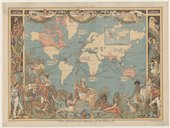
Titre(s) : Imperial federation. Map of the world showing the extent of the British empire in 1886. Special information furnished [Document cartographique] / by capitain J. C. R. Colomb, ,...
Publication : London : Maclure and Ce, [1886]
Description matérielle : 1 flle ; 77 x 57 cm
Auteur(s) : Colomb, J. C. R. (18..-18..?). Cartographe
Sujet(s) géographique(s) :
Monde -- BritanniqueEmpire
Typologie : Carte
Identifiant de la notice : ark:/12148/cb40734828v
Notice n° :
FRBNF40734828
 Cette notice appartient à l'univers images et cartes
Localiser ce document(2 Exemplaires)
Document numérique :
1 partie d'exemplaire regroupée
IFN-53062098
support : lot d'images numérisées
support : lot d'images numérisées


